Tuesday, May 2, 2006

Fort Frederick

Getting to Big Pool

Start Mile: 112
End Mile: 112.5
Time: 50 minutes
When: Evening

Directions: From Williamsport, take MD 68 to MD 56. Make a left on MD 56 and follow it to Four Locks Road. There are several one-lane bridges on MD 56. The entrance to Fort Frederick is a left off of 56. There is plenty of parking. Make the first left for the road to the canal or go straight to park near the attractions.


It has been a while since we were able to get to the river so when I had a break this afternoon, we jumped in the truck and headed for Fort Frederick. This is a big place so it will take a while to explore.


There was some type of traffic tie up that had Route 11 and Interstate 81 tied up. Without another way over the river, we cooled out heels for a half hour. Eventually, we made it to Williamsport and slipped through the back roads to escape.

There is a gift shop near the entrance to the fort. It was closed by the time we got there.


The C&O Canal crosses the road through the State Park. This is a popular bicycle spot. A couple horses were ahead of us today.


Big Pool is a natural basin. It was used to turn canal boats when that was needed but now it is popular for fishing.


There is a small launch ramp in the State Park. This is as close to a lake as you get in this part of Maryland.


The water on the river side is a bit less inviting.


We spotted a couple of Canadian Geese. Buck is not sure what to do with them. On one hand, he hates water. On the other, he likes fowl. What's a dog to do?


At this point we caught up to the horses. They were doing what horses do so we turned around and headed home.

Read more...

Monday, March 20, 2006

Lock 44

Lockwood Road to the Cushwa Basin

Start Mile: 99
End Mile: 99.6
Time: 50 minutes
When: Evening 3/20/06

Directions: Route 11 to Williamsport. Take 68 east. Just before I-81, turn right onto Lockwood Road. Turn right at the storage units. There is not a parking area but there is room for about 4 cars before you get to the power plant.


I just wasn't feeling the love at work today and I was ready for a break by five. I had a lot to do so a quick walk at Williamsport was all we could get in. I chose to park at Lockwood Road to avoid the visitor center.


There is always a lot of water in the canal at Williamsport. There were several sets of ducks around today but this particular pair seemed to pace us as we headed west.


Lock 44 is a substantial structure with a bridge going across it to an alternative parking area.


This lock house sits between Lock 44 and the power plant.


The R Paul Smith Power Station is a coal fired steam turbine electrical generation facility. It towers over the lock pulling water from the river and burning trucked in coal.


River View Cemetery sits on the Williamsport side of the canal. There is a temporary bridge across the canal to the road running past it.


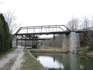
The Bollman Bridge is being rebuilt again. This bridge was first built in the 1870s. I don't know how many times it was repaired. Heavy vehicles towing boats to the launch ramp did it in.


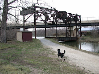
My favorite railroad bridge on the canal is this lift bridge that used to allow coal to be hauled to the power station. It is designed to lift out of the way of the canal. Very Rube Goldberg.


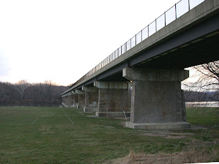
Route 11 crosses the Potomac River at River Park in Williams Port.


The buildings of the Cushwa Basin are restored.

Read more...

Saturday, March 18, 2006

Praether's Neck

Four Locks Road to McCoys Ferry

Start Mile: 109
End Mile: 110.2
Time: 1 Hour
When: Morning 3/18/06

Directions: From Williamsport, take MD 68 to MD 56. Make a left on MD 56 and follow it to Four Locks Road. There are several one-lane bridges on MD 56. Follow Four Locks Road to the signs for the boat ramp. There are several one-lane tunnels on Four Locks Road. There is parking at the boat ramp.


I got up early so we could get in a couple miles before Buck had to go to obedience training. Yesterday's walk at Four Locks left me excited for more so I thought we would start there and head west to McCoys Ferry.


It is easy to forget that mules were the main power source for the canals. As a reminder, a mule barn stands at Four Locks.


We started the walk at Lock 50. There is still a small waiting shed at the lock.


It was a cool but sunny day. There was plenty of wildlife around us but it was hard to get a good look. The number of wild turkeys on this stretch is unbelievable.


As the canal joins the river, there is a small channel. I assume this was how water was directed back to the canal.


At about a quarter mile from marker 109, the river meets back up with the canal.


This is the remains of a stone culvert.


According to Mike High, North Mountain Campsite actually looks out on North Mountain and behind it on the other side of the canal is Fairview Mountain. I always thought North Mountain was the ridge running toward McCoys Ferry.


There is a stop lock before McCoys Ferry. It is being slowly consumed by nature.


McCoys Ferry was notable as the launching point for J.E.B. Stuart's raid into Pennsylvania. Now it is a recreation area with a boat launch and a camping area.


It never fails that a freight train is running along the old Western MD Railroad tracks. The train was gone before we made it to the bridge just beyond McCoy's Ferry.


On the way out we took a look around this old building that sits off of Four Locks Road. I have no idea what it was used for but as usual, I like to look at old buildings.

Read more...

Tuesday, March 14, 2006

Yogi Bear

Charles Mill to Four Locks

Start Mile: 109
End Mile: 108
Time: 1 Hour
When: Evening 3/14/06

Directions: From Williamsport, take MD 68 to MD 56. Make a left on MD 56 and follow it to Four Locks Road. There are several one-lane bridges on MD 56. Follow Four Locks Road to the signs for the boat ramp. There are several one-lane tunnels on Four Locks Road. There is parking and portable toilets at the boat ramp.


It was another stress filled day at the bit mines so we took off a few minutes before the 5 o’clock whistle blew. I don't know what made me pick this section for a walk. Maybe all of the stone work yesterday put me in the mood for the cool tunnels you have to drive through to get here.


It cooled off a lot since yesterday. There were no boats launching for some after work fishing. This is a nice launch facility if you don't mind the tunnels. There are nice picnic areas with grilles.


There are a lot of cool old structures at Four Locks. I think this was the old feed store.


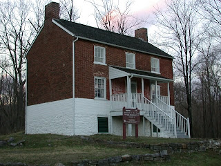
I don't know what this large house is, but I love the stone work.


This was the lock house. One lock house was used for all four locks.


No tour of Four Locks is complete without seeing the locks. They head west starting with Lock 47.


Lock 48.


Lock 49.


Lock 50.


As you head east from Four Locks, there are rock formations to your left. They rise and fall quickly and you don't notice them much when there are leaves on the trees.


On the West Virginia side is Yogi Bear recreational area. It seems to stretch for miles. I'd like to know who named it.


Off the path a bit just before mile 108 is the ruins of Charles Mill. There are some private homes beyond the mill.


We turned back after mile 108. It was getting colder and darker so we picked up the pace. It was good to get back to the truck.


Bye.

Read more...

Monday, March 13, 2006

East of Williamsport Revisited

Cumberland Valley Railroad bridge to Lockwood Road

Start Mile: 99
End Mile: 97.3
Time: 1.5 hours
When: Evening 3/13/06

Directions: Route 11 to Williamsport. Take 68 east. Just before I-81, turn right onto Lockwood Road. Turn right at the storage units. There is not a parking area but there is room for about 4 cars before you get to the power plant.


It was a long hard day that included working through lunch and a couple miserable meetings. I needed a break and the unseasonable weather made it down right hot. Buck was suffering from cabin fever and kept looking longingly at the truck in the driveway. I put on some shorts and we were off.


You can see the Paul R Smith Power Station at the entrance to the trail. This is a coal-fired plant that has been here since the 20s.


You get the first good look of the Potomac about 1/8 mile into the walk. There is a clearing where some power lines cross the river. Another 3/8 mile and you are under I-81. The truck traffic never stops and can be heard for most of the walk. Just west of the highway is a large spring. It doesn't look like much in pictures, but is fairly impressive in person.


There are few landmarks until the Winchester Western Railroad Bridge at mile 97.4. I wonder what it would be like to be on the trail when a train goes by? The railroad is not nearly as high as the highway.


This is the remains of the Cumberland Valley Railroad Bridge. I love the old stonework of the embankment and the piers. The entire hillside is covered in stone.


It was getting dark so we double-timed it back to the truck just in time for a rain shower.

Read more...